Formation initiale > Licence professionnelle
Vocational bachelor's degree in surveying and geomatics
Specialisation in cartography, topography and geographic information systems
Niveau admission general high school diploma, STI2D high school diploma, STL high school diploma
Diplôme délivré Vocational bachelor's degree
Durée 3 years
Lieu Géodata Paris
Frais de scolarité See details in “Tuition Fees” tab
Rediffusion live présentation de la Licence professionnelle Géomètre-Géomaticien
By clicking on play, you accept cookies from YouTube
Sous-titres
Bonjour à toutes et à tous, bonsoir même.
Je vais commencer par me présenter. Je m’appelle Franck Terte, je suis enseignant en topométrie à l’école et également responsable du cycle de licence professionnelle Géomètre-Géomaticien.
Dans un premier temps, comme l’a indiqué Wendy, je vais vous présenter rapidement la formation pendant une vingtaine de minutes. Ensuite, Timothé prendra la suite pour vous parler davantage de la vie étudiante, puis nous répondrons à vos questions.
Je vous demanderais simplement de couper vos micros afin d’éviter les bruits parasites.
Je vais maintenant partager le PowerPoint. Est-ce que tout le monde le voit ? Très bien, nous allons pouvoir commencer.
Présentation du métier et de la formation
Nous allons d’abord définir ce que recouvrent les notions de géomètre et de géomaticien.
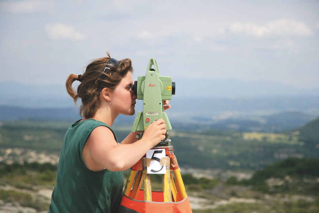
Vous avez certainement déjà une idée du métier de géomètre : ce sont les personnes que l’on voit parfois dans la rue avec des appareils de mesure pour réaliser des relevés topographiques et produire des plans. Ici, vous voyez par exemple nos étudiants dans un village de Provence, près de Forcalquier, en train d’effectuer le relevé d’un amphithéâtre afin de le restituer sous forme de plan à l’aide d’un logiciel de DAO comme AutoCAD.
À côté de cela, il y a la géomatique. Le géomaticien travaille davantage sur la collecte, le traitement et l’analyse des données géographiques numériques. Il utilise notamment des logiciels SIG, c’est-à-dire des systèmes d’information géographique.
Vous utilisez déjà probablement des applications de géomatique au quotidien sans forcément le savoir. Les GPS de navigation, Google Maps ou encore les applications cartographiques sur smartphone en sont des exemples très concrets.
L’idée de la formation est justement de réunir ces deux dimensions : la collecte de données sur le terrain et leur traitement numérique. L’objectif est de former des professionnels polyvalents capables d’intervenir sur toute la chaîne, depuis l’acquisition des données jusqu’à leur traitement, leur analyse et leur diffusion.
Collecter l’information géographique
La collecte des données correspond davantage au métier historique du géomètre.
Pour cela, nous utilisons différents instruments comme des tachéomètres, des GPS professionnels, des drones équipés d’appareils photo, des scanners laser ainsi que des images aériennes et satellitaires.
Vous avez peut-être déjà entendu parler du LiDAR. Il s’agit d’un scanner laser embarqué sur un avion ou un drone permettant de produire des modélisations 3D très précises du terrain.
Traiter et analyser les données
Une fois les données collectées, il faut les traiter et les analyser.
Par exemple, nous pouvons produire des orthophotographies, c’est-à-dire des images aériennes géométriquement redressées ayant la précision d’une carte.
Ces données sont ensuite exploitées dans des SIG afin d’analyser l’occupation des sols, étudier la végétation, gérer les risques naturels, modéliser des inondations, produire des modèles numériques de terrain ou encore aider les collectivités territoriales à prendre des décisions.
Diffuser l’information géographique
La dernière étape consiste à diffuser l’information.
Cela peut prendre différentes formes comme des plans papier, des cartes numériques, du webmapping ou encore des modèles 3D.
Vous utilisez déjà ce type de données sur Géoportail, le portail cartographique de l’IGN.
Nous réalisons également des modélisations 3D complètes, notamment lors des travaux de terrain à Forcalquier.
Les débouchés
Les débouchés sont nombreux et variés.
Nos diplômés peuvent travailler dans les services SIG des collectivités territoriales, dans les grandes entreprises de réseaux comme EDF, Veolia ou la RATP, dans des bureaux d’études et cabinets de géomètres, dans la conservation du patrimoine, dans le BIM et la modélisation 3D, dans le développement web cartographique ou encore dans l’imagerie satellite et la télédétection.
La formation possède donc une forte dimension numérique avec du développement informatique et de la programmation.
Présentation de la licence professionnelle
Notre licence professionnelle est une formation en trois ans, ce qui est relativement rare en France pour une licence professionnelle.
Historiquement, nous avions un cursus bac +2 puis une licence professionnelle en un an. Nous avons finalement fusionné les deux pour créer une formation complète en trois ans.
La formation est proposée en partenariat avec l’Université Gustave Eiffel et Panthéon-Sorbonne.
Géodata Paris est une école composante de l’Université Gustave Eiffel, mais reste administrativement indépendante car elle dépend de l’IGN, l’Institut national de l’information géographique et forestière.
Organisation des études
La première année se déroule principalement à Marne-la-Vallée, de septembre à mars.
Les enseignements portent surtout sur la topométrie, la géodésie, la photogrammétrie, la télédétection, la DAO, les mathématiques, la cartographie, l’informatique et les sciences humaines.
À partir d’avril, les étudiants partent environ deux mois à Forcalquier pour des travaux de terrain.
Les frais de scolarité correspondent aux droits universitaires classiques.
En deuxième année, l’accent est davantage mis sur le numérique, les SIG, l’informatique et les projets.
Les étudiants gagnent progressivement en autonomie et travaillent sur des projets concrets répondant à de véritables besoins.
Un nouveau stage terrain est organisé en fin d’année.
En troisième année, deux parcours sont possibles : la formation initiale avec spécialisation imagerie ou l’alternance.
Les enseignements portent notamment sur l’imagerie spatiale, la télédétection, l’intelligence artificielle, la programmation et la cartographie avancée.
Les étudiants en formation initiale effectuent également un stage obligatoire.
Niveau attendu et mathématiques
Nous insistons beaucoup sur les mathématiques car elles sont au cœur de nombreuses disciplines enseignées comme la géodésie, la photogrammétrie, la télédétection ou encore la topométrie.
Il est donc conseillé d’avoir un bon niveau en mathématiques, idéalement avec la spécialité maths au lycée.
Cela dit, nous accueillons aussi des profils STI2D, des étudiants ayant suivi mathématiques complémentaires ou encore des parcours plus atypiques.
La motivation et le travail personnel restent essentiels.
Vie étudiante
Timothé prend ensuite la parole pour présenter la vie étudiante.
Il explique que l’école est à taille humaine, ce qui facilite l’intégration et la création de liens entre étudiants.
Il évoque également les associations étudiantes, les clubs, les projets collectifs ainsi que l’expérience très marquante des stages terrain à Forcalquier.
Questions-réponses
Les échanges se poursuivent ensuite autour du niveau en mathématiques, des modalités d’admission, des concours fonctionnaires, des possibilités de poursuite d’études, des logements, des débouchés et de l’organisation de la formation.
La réunion se termine par des remerciements et une invitation à contacter l’école pour toute question complémentaire.